

From Overland Trail stagecoaches to gold-rush ghost towns, tie-hack logging camps to a monastery tucked in the hills, Northwest Larimer County wears its history in the open — if you know where to look. Below are the region’s landmark historic sites, drawn from the National Register of Historic Places, Colorado’s historical societies, and the people who have kept these stories alive. Each links to its own page with directions, and every location is plotted on the map at the bottom.
Virginia Dale & the Overland Trail
Virginia Dale Stage Station
Established in 1862 by Overland stage agent Joseph “Jack” Slade — who named it for his wife — Virginia Dale was a home station on the Overland Trail and the last stop before the mountain passes. Robbed and fought over in its heyday, the original station still stands, cared for by a local historical society, and is one of the few Overland Trail stations left. Listed on the National Register of Historic Places in 1985. Details & directions »
Abbey of St. Walburga
A community of Benedictine nuns relocated to this quiet Virginia Dale valley in 1997, building a working monastery and ranch on donated land and carrying forward a monastic lineage that traces to Eichstätt, Germany. It is a serene, living piece of high-country history — visitors are welcome to the chapel and gift shop. Details & directions »
Livermore & the Eastern Foothills
Livermore Hotel & General Store
This 1890 wood-frame hotel and general store anchored the little community of Livermore and doubled as a stage way-station on the route between Fort Collins, Laramie, and Red Feather Lakes. It is one of Northwest Larimer County’s best-preserved frontier commercial buildings. Listed on the National Register in 2001 (Colorado site 5LR.699). Details & directions »
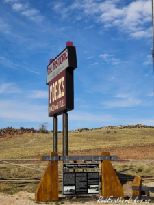
The Forks Mercantile
No trip up to Red Feather Lakes is complete without a pit stop at the legendary Forks Mercantile! Sitting right at the junction of Highway 287 and Red Feather Lakes Road, this
Solomon Batterson Ranch
A historic working ranch in the Livermore foothills, the Solomon Batterson Ranch became Colorado’s very first National Register-listed Rural Historic Landscape in 2010 — recognized not just for its buildings but for an entire living, worked agricultural landscape. (Private property; location approximate.) Details & directions »
Cherokee Park Ranch
Step back in time at this iconic, all-inclusive dude ranch that has been operating since 1886. Tucked away in Livermore, they offer an unforgettable Western experience complete with beautiful lodge suites, daily horseback riding, guided fly fishing, and incredible homestyle meals. It’s a bucket-list family vacation steeped in true Colorado history. Details & directions »
Buckhorn Ranger Station Historic District
Built by the Civilian Conservation Corps between 1933 and 1941, this Forest Service ranger station west of Masonville is a well-preserved example of Depression-era CCC craftsmanship in the Roosevelt National Forest. Added to the National Register in 2022. Details & directions »
Red Feather Lakes & the High Country
Manhattan Ghost Town
Gold discovered near Seven Mile and Elk Horn creeks in 1886 gave rise to Manhattan, a mining town platted in 1887 with its own post office. The boom faded, and by the 1930s the Forest Service had removed the last buildings as a fire hazard — but the Manhattan cemetery still remains, about four miles north of Rustic. Details & directions »
Deadman Fire Lookout
A steel fire tower built in 1960 on Deadman Hill, replacing a wooden lookout the CCC raised in the late 1930s. Reached by County Road 74E west of Red Feather Lakes, it is listed on the National Historic Lookout Register and still commands one of the finest views in the county. Details & directions »
More of the high country’s past. The Red Feather Historical Society keeps the stories of places that no longer stand on any map: the Log Cabin Stage Station (1888–1942) and the 1908 Log Cabin School on County Road 74E; the Elkhorn School, which began as the Manhattan mining-town school around 1889; and the pioneer Swanson, Maxwell, Phantom Canyon, and Hardin ranches scattered through the Lone Pine and Livermore valleys. Most sit on private land and their precise locations aren’t published — but their history is woven through every mile of this country.
The Cache la Poudre Canyon
Ted’s Place
Sitting right at the intersection of US 287 and Hwy 14, Ted’s Place is the legendary gateway to the Poudre Canyon. This is your absolute last stop for fuel and quick road trip snacks before you head west into the mountains. Fill up the tank here, because it’s a long, wild road ahead!
- Origin: Originally named the Poudre Canyon Filling Station, it became known as “Ted’s Place” due to its owner, Ted Herring, a local figure who later served in the Colorado legislature.
- Function: It was a crucial stop for travelers to the “Trout Route” (Poudre Canyon), selling fishing licenses, tackle, gas, and supplies. It was renowned for homemade bean soup and sandwiches.
- Structure & Legacy: In the 1930s, it featured a distinctive rustic bungalow. Although the original building was torn down by Conoco in 1989, the location retains the name “Ted’s Place” on maps.
Arrowhead Lodge
Built in the early 1930s along the Cache la Poudre River about 32 miles up the canyon, Arrowhead Lodge was a beloved summer resort camp until 1984, when it passed to the U.S. Forest Service. Today the main lodge serves as the Arrowhead Lodge Visitor Center for the Cache la Poudre Wild & Scenic River. Listed on the National Register in 1992. Details & directions »
Sportsman’s Lodge
Operating continuously since 1931, Sportsman’s Lodge is a living piece of Poudre Canyon history. They offer 12 historic cabins, RV spaces, and an incredibly nostalgic onsite and online gift store (Smith Dry Goods). It truly feels like stepping back into an era of golden-age mountain exploration and adventure. Details & directions »
The Mishawaka
Perched on the banks of the Cache la Poudre, the Mishawaka has welcomed canyon travelers since the early 1900s and grown into one of Colorado’s most storied riverside music venues. Its amphitheater still draws crowds to the water’s edge. Details & directions »
Columbine Lodge & Poudre Park
Started as Columbine Camp in the late 1920s by a Fort Collins grocer, this canyon resort in the old Poudre Park subdivision (platted 1919) offered cabins, dining, a store, and fishing for generations of visitors. It is being reborn today as ‘Riverside Colorado.’ Details & directions »
The Upper Poudre & Cameron Pass
Chambers Lake Dam
Named for a trapper who camped here in 1858, Chambers Lake was dammed in 1887 to store irrigation water. On June 8, 1891, that dam gave way — the flood destroyed every bridge to Fort Collins and washed the downstream town of Poudre City off the map. The rebuilt reservoir sits at about 9,300 feet in the upper Poudre high country. Details & directions »
Pingree Park Tie Camp
In the 1860s, frontiersman George Pingree ran a railroad-tie logging camp in the South Fork valley that now bears his name. Tie hacks cut ties by hand, floated them down the Poudre toward LaPorte, and hauled them to the railroad in Wyoming — one of the region’s earliest industries. (Location approximate.) Details & directions »
Long Draw Reservoir
High on La Poudre Pass Creek at over 10,000 feet, Long Draw Reservoir was built to divert and store water from the very headwaters of the Cache la Poudre — a landmark of early-20th-century Colorado water engineering near the crest of Cameron Pass. Details & directions »
Explore Every Site on the Map
Pan and zoom the map below to find each historic site; click any marker to open its page with a photo and driving directions.
History and coordinates compiled from the National Register of Historic Places, USGS, History Colorado, the Red Feather Historical Society, Historic Larimer County, and the U.S. Forest Service. A few backcountry locations are approximate; several private ranch and school sites are documented but not pinned. Spot an error or have a story to add? We’d love to hear it.