

Trails · Cameron Pass & State Forest State Park
Lake Agnes Trail
A short, steep climb to a sapphire alpine lake cupped beneath the jagged Nokhu Crags.
Toggle Terrain / USGS Topo / Satellite / Street (top-right) · route © COTREX/CPW · tap a marker for waypoints
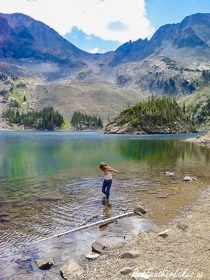
Lake Agnes is the kind of payoff that feels wildly out of proportion to the effort. Less than a mile of dirt trail climbs from the trailhead at the end of Lake Agnes Road into the high, rocky heart of State Forest State Park, on the west side of Cameron Pass. It's short but honest work — you gain the lake basin quickly — and then the trees fall away and the whole scene opens: a clear alpine tarn ringed by talus and krummholz, with the serrated spires of the Nokhu Crags standing straight up out of the far shore. This is the northern edge of the Never Summer Mountains, and it looks every bit the part.
Because it's so short and so spectacular, this is one of the busiest little trails on the pass — expect company on a summer weekend, and come early for a parking spot at the small trailhead lot. COTREX has it as a 0.9-mile dirt hiking trail managed by State Forest State Park; dogs are welcome on leash, and it's foot travel only (no bikes, no stock). Everything up here is genuinely high country, so snow can linger into early summer and afternoon thunderstorms build fast — check current conditions and pass requirements with State Forest State Park before you go.
Trail Facts
Length
0.9 mi
Elevation
10,260 → 10,680 ft
Elevation Gain
+450 ft
Type
Trail
Uses
Hike
Bikes
Not allowed
Stock / Horse
Not allowed
Dogs
On leash
Surface
Dirt
Manager
State Forest State Park
Getting There
Lake Agnes is in State Forest State Park, on the west side of Cameron Pass off CO-14. From the pass, drop west and watch for the signed turnoff toward Michigan Reservoir and the Lake Agnes trailhead; a short, rough gravel road (Lake Agnes Road — high-clearance is wise, and it's closed by snow in the off-season) climbs to the small trailhead lot where the hike begins. A valid Colorado state parks pass is required to enter State Forest State Park — confirm the current road status, parking, and pass details with the park before you drive up.
| 0.0 mi | Lake Agnes Trailhead — end of Lake Agnes Road |
| 0.9 mi | Lake Agnes — alpine lake below the Nokhu Crags |
Know Before You Go
- Foot travel only. COTREX lists no bikes and no stock on this trail — it's a short hikers' route, and its popularity means keeping to the tread really matters up here.
- Dogs on leash. Four-legged hikers are welcome, but keep them leashed to protect the fragile alpine basin and other visitors.
- State park pass required. Lake Agnes sits inside State Forest State Park; a valid Colorado state parks pass is needed to enter — buy or confirm it before you head up.
- Check current conditions. This is genuine high country: snow can linger into early summer, afternoon storms build quickly, and the access road closes seasonally — verify with State Forest State Park before you go.
On the Trail
Photos © Red Feather Lakes Travel Guide — shot on the trail.
Built by Many Hands — Give a Little Back
Love this guide? Wear it. Every hat, tee, and cozy layer in our Red Feather Lakes collection helps us keep mapping trails and keeping this guide free — mountain apparel designed right here in the high country, with more trail gear on the way.
Shop the Collection →These trails don't tend themselves either. Every mile is watched over by volunteers and public stewards we lean on to bring you this guide — if you love these mountains, please pitch in for them too:
- Poudre Wilderness Volunteers — trail patrols & the official trail description Donate →
- Colorado Parks & Wildlife / COTREX — the mapped trail route & statewide trail data Donate →
- Arapaho & Roosevelt National Forest (USFS) — the public land itself Support →
- OpenStreetMap contributors — the Street basemap Donate →
- Google & USGS — trailhead location, ratings & topographic maps
Trail details compiled by the Red Feather Lakes Travel Guide from the sources above. Photography by us — more of our own trail images coming as we hike them.